Overview
Mining and Rehabilitation Demonstration Pit
The Mining and Rehabilitation Demonstration Pit (MRDP) is a reduced-scale trial designed to test how land can be effectively rehabilitated under real world conditions. It forms part of GCM’s reporting and delivery obligations under retention licence RL2026, which requires us to undertake large-scale rehabilitation trials.
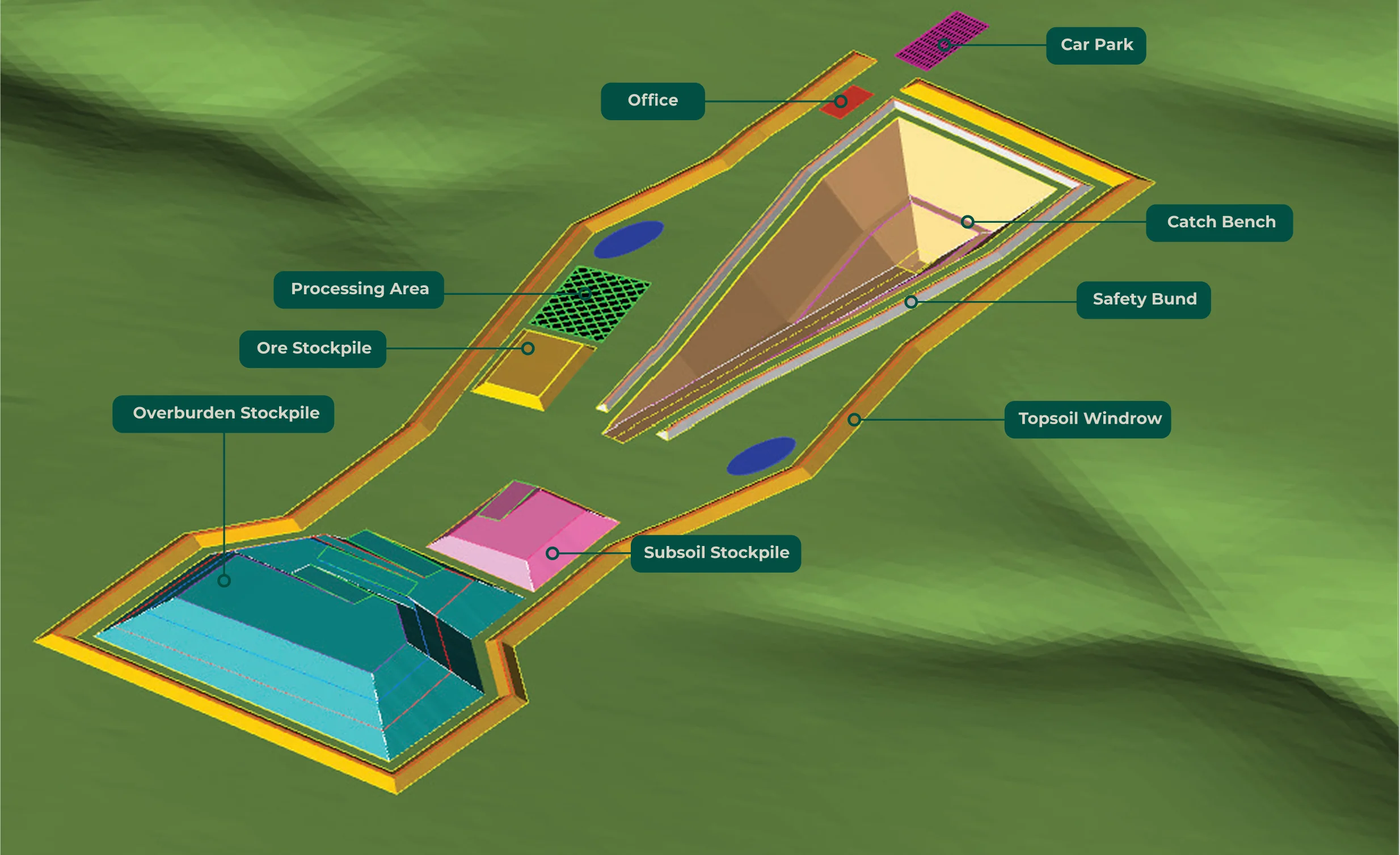
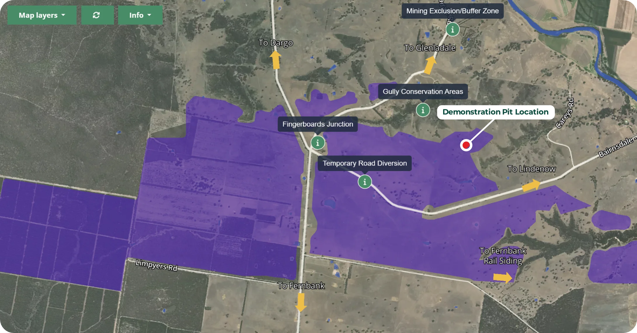
The MRDP is located on the eastern side of the project area and will be around 170 metres long, 55 metres wide and up to 22 metres deep. The trial will also test excavation techniques, material behaviour, water management, tailings characteristics, landform stability and rehabilitation techniques and outcomes, providing specific data to support the project’s environmental studies.
These activities create the real-world conditions needed to understand how soils, water and tailings behave during excavation, backfilling and rehabilitation. The results will track soil structure, vegetation establishment and long-term erosion control, showing how our safeguards perform under practical conditions and where further refinements can strengthen environmental performance.
The MRDP will sit alongside and inform a range of technical and environmental studies currently underway, including assessments of air quality, landscape and visual, water, noise and vibration, agricultural and horticultural, radiation, social impact, and ecology.
You can read summary scopes of these studies on our monitoring and studies page.
Real-world testing
What will we test and trial with the MRDP:
- Geological information such as soil permeability, water retention, density and moisture content.
- Tailings design parameters including consolidation, permeability, strength and water recovery.
- Groundwater quality and monitoring of long- term seepage.
- Soil charachteristics including soil strength, bearing capacity, and soil chemistry.
- Soil improvement methods to support strong revegetation outcomes.
- Species selection and rehabilitation practices to optimise vegetation growth.
- Monitoring of environmental parametres including air quality, noise, and water quality that can input into the modelling for the full- scale project.
- Background radiation levels to identify any changes before, during and after earthworks.
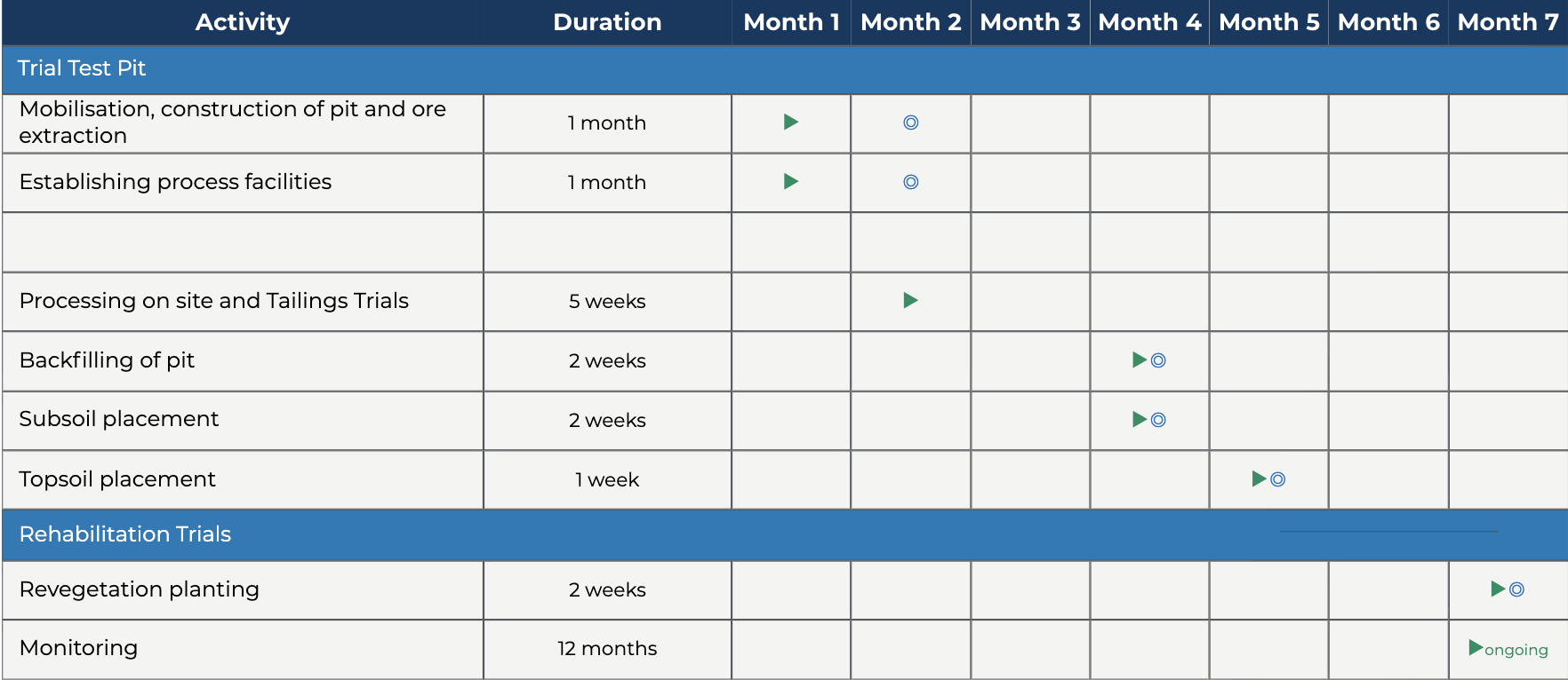
Status: MRDP Work plan Approved
A Work Plan for the MRDP has been approved by Resources Victoria, with work scheduled to commence in April 2026.
Indicative Timelime
Information Sheets
Community Resources
GCM is committed to providing clear, accessible information about the MRDP. Community members will also be able to visit the site during the trial, and study results will be published as part of the environmental approvals process. You can read more in our MRDP Community Engagement Plan and Information Sheet.
Frequently asked questions
We know the community is looking for clear information about how the Mining Rehabilitation and Demonstration Pit (MRDP) will work. The FAQs below respond to some of the key questions we’ve heard.
If you have other questions or would like more information, please visit our Contact page to get int touch with the team.
Why do a demonstration Pit?
TThe MRDP is a condition of our Retention Licence, which requires us to run large-scale, real-world rehabilitation trials. To do this properly and prove to the community that rehabilitation methodology work in practice, we determined it necessary to simulate similar conditions to the full mine in a safe, reduced-scale setting. This is industry best practice and it helps us build a better, fully validated project based on real world, on-site results.
How big is the demonstration pit?
The pit will be about 170 metres long, 55 metres wide and up to 22 metres at its deepest point. That’s roughly the length of the MCG playing field, about the width of one Olympic swimming pool, and around seven stories deep.
The depth is close to the average ore depth across the whole project area, and the site has geological and soil conditions that closely match those expected during mining. This allows us to replicate real mining, backfilling, and rehabilitation in a representative location.
Results from the trial will be compared with our geology drill-hole database to help validate the mine design.
Is this the start of commercial mining?
No – the MRDP is not the start of commercial mining and is considered an exploration activity, and any material we extract won’t be sold or used commercially. Extracted minerals will be kept in bulker bags and stored on GCM property in a shipping container and will be used periodically for further metallurgical testing as required.
How will dust from the MRDP be controlled?
Dust will be managed through a combination of proven prevention and control measures. Active work areas will be kept damp using water carts, temporary stockpiles will be hydro-mulched, and earthwork areas will be backfilled and covered quickly to limit exposed soil. During periods of high wind, where it is deemed necessary, we will pause works to minimise dust impacts.
A core purpose of the MRDP is to measure and validate dust behaviour in real conditions. Dust data collected on site will feed directly into our air quality studies, being undertaken by AECOM. The newly installed second weather station is located very close to the site and we can measure dust levels against weather data specific to the site. You can read the scope of our air study here.
How will noise from the MRDP be managed?
Work will be limited to daylight hours only – 7am to 6pm on Monday to Friday, and 7am to 1pm on Saturday – with no night works at any stage. We will notify neighbours before works begin, including clear information about when to expect noise. A community hotline will be open throughout the works, and we encourage residents to contact us with any questions or feedback.
A key purpose of the MRDP is to measure actual noise levels on the site. These results feed directly into our noise and vibration studies, being undertaken by AECOM, with results to be published as part of the environmental approvals process. You can read the full study summary scope here.
How will the MRDP impact local roads and traffic?
Access to the MRDP is via an existing farm track that connects to Carey’s lane, which joins Bairnsdale-Dargo Road. The farm track is already used for agricultural equipment and will be upgraded to smooth out a few sections with steep crossfall so larger equipment can safely access the site during the mobilisation phase. The extent of earthworks is shallow and generally limited to a maximum of 0.5m below the existing ground level over a maximum width of 7.5m.
Carey’s Lane is a single access road with only one dwelling at the end, and that property is owned by GCM. Land on both sides of Carey’s Lane is either owned by GCM or under agreement to purchase and the traffic impact during mobilisation and operation of the MRDP is therefore expected to have limited impact on other users.
What impact will the MRDP have on native vegetation?
The MRDP site was selected for its low-impact location, particularly in relation to native vegetation and drainage. In total, four (three dead, one living) on-site trees could be impacted by the MRDP (impacted is defined as more than 10 per cent of a trees notional root zone being disturbed). These trees will not be removed during the trial but due to the proximity of the works, are assessed as if they will be, and will therefore be offset.
What areas of Cultural Heritage may be disturbed for the roadway and the test pit site?
The MRDP site and access track have been surveyed and approved under a Cultural Heritage Management Plan (CHMP) in consultation with GLaWAC. We will continue to work closely with GLaWAC.
Will the MRDP affect groundwater?
No – the groundwater table in the project area sits around 70 metres below the surface, while the Demonstration Pit will reach a depth of only 22 metres. This means there is almost 50 metres of natural, unsaturated sand separating the pit base from the regional water table.
The MRDP does not extract groundwater and there is no perched aquifer within the MRDP. A primary and secondary underdrainage system will be installed under the tailings and at the base of the pit, to allow for monitoring and any extracted water will be returned back to the process water tanks for reuse.
What local opportunities will be available through the MRDP?
GCM is investing significantly in local industry, with Bairnsdale companies Whelan’s Group Investments (WGI) and Riley Earthmoving among up to 12 local firms engaged through more than $1 million worth of procurement contracts for the demonstration pit in construction, civil works and site services. The MRDP will give us an opportunity to trial and refine our local jobs and procurement policy so that East Gippslanders are well placed for future opportunities.
Are there any radiation impacts, and how will they be managed?
Low levels of Naturally Occurring Radioactive Material (NORM) are found in Gippsland’s mineral sands. Mining and processing of the ore results in it being concentrated to low levels that require a management license from the Department of Health. Only the concentrate produced has low level radiation, the tailings that is returned to the void has less NORM content than the ore when it was mined.
Even with low activity levels, the MRDP will operate under a Radiation Management Plan, and we will measure background radiation before, during, and after earthworks to identify any changes. All results will feed directly into the independent radiation studies being conducted by DBH Radiation Pty Ltd. You can read the full radiation study summary scope here.
How will GCM prevent soil erosion or tunnelling during the MRDP?
We recognise that tunnel erosion continues to impact parts of East Gippsland. That’s why, through the Demonstration Pit, soil behaviour and management approaches will be trialled and tested at several depths, ensuring our practical measures prevent tunnelling and erosion in real conditions.
Water management is a key safeguard against tunnelling, and we have strict water management measures in place for the trial to manage water, including rainfall runoff and avoiding concentration of water flows. These controls will provide site specific evidence to inform the project’s environmental assessments and, if approved for operations, guide the measures carried into the project.
GCM will:
- Establish vegetation as soon as possible post backfilling of the pit, with appropriate vegetation type
- Survey the land before, during and after the demonstration pit works to monitor and manage settlement and inform design
- Ameliorate any sodic subsoils (with gypsum)
- Test and trial subsoil management approaches
- Following revegetation, maintain groundcover at all times and measure runoff water quality
- Fence the site to avoid over-grazing and allow controlled grazing as part of the trial
The results from this MRDP will feed directly into our soil studies, being undertaken by SLR. You can read the full soil summary scope here.